
Contribution of Magnetic Resonance Soundings for characterizing water storage in the unsaturated zone of karst aquifers
Understanding the role of the unsaturated zone in aquifer recharge and contaminant attenuation processes is a major challenge for the protection and management of karstic water resources. We present the potential of the MRS (Magnetic Resonance Soundings) geophysical method for characterizing the vadose zone of karst aquifers composed of epikarst and infiltration layers. To investigate the hydraulic functioning of the Durzon karst system located on the Larzac plateau (Southern France), we used MRS method at sixteen sites. The MRS results have been compared to available geological information and to core water content measurements. The remarkable spatial variability of the MRS response observed in the study area makes it possible to determine ranges of water storage properties in relation to the lithology of the investigated carbonate formations (dolomite, marly and siliceous limestone). All soundings show either constant or increasing MRS water content with depth, which demonstrates that the infiltration zone may be the major water storage entity for permanent water storage, with important consequences for recharge quality and quantity. These results show the feasibility and potential of the MRS method for the characterization of the karst unsaturated zone and for understanding the vertical distribution of water content, which impacts the overall functioning of karst systems.
(Naomi Mazzilli1, Marie Bouchery2, Konstantinos Chalikakis1, Anatoly Legchenkoy2, Hervé Jourdez3 and Cédric Champollion4)
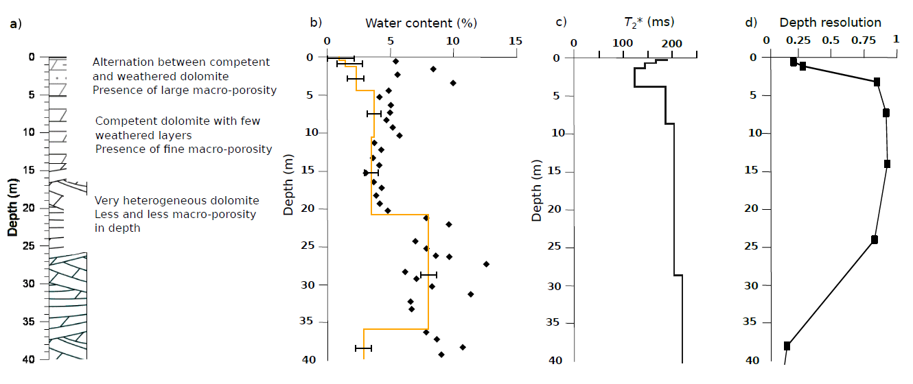
Comparison of MRS results and core samples from a drillhole performed at the center of H3 site:
a) simplified log resulting from a synthesis of visual observations performed on 3 different boreholes,
b) core sample water content (markers), and MRS (% – line),
c) T2 (z) (ms), d) depth resolution of the MRS model.
Download: WP62_geophysics_Mazzilli
- UMR 1114 EMMAH (UAPV/INRA), Université d’Avignon et des Pays de Vaucluse, 33 rue Pasteur, 84000 Avignon, France.
- UMR 5564 LTHE (IRD/UJF/CNRS/G-INP), BP 53, 38041 Grenoble, France.
- UMR 5569 HSM (CNRS/IRD/UM2), Université Montpellier 2 CC MSE, 34095 Montpellier cedex 5, France.
- UMR 5243 (CNRS/UM2) Géosciences Montpellier, Université Montpellier 2 CC 60, 34095 Montpellier cedex 5, France.