Tag Archives: Hydrogéologie

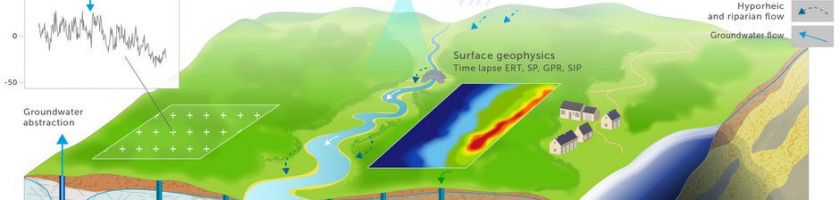
Active-Distributed Temperature Sensing to continuously quantify vertical flow in boreholes

We show how a distributed borehole flowmeter can be created from armored Fiber Optic cables with the Active-Distributed Temperature Sensing (A-DTS) method. The principle is that in a flowing fluid, the difference in temperature between a heated and unheated cable is a function of the fluid velocity. We outline the physical basis of the methodology and report on the deployment […]

Read more

Detecting different water table levels in a shallow aquifer with combined P-, surface and SH-wave surveys: Insights from VP/VS or Poisson’s ratios

When applied to hydrogeology, seismicmethods are generally confined to the characterisation of aquifer geometry. The joint study of pressure- (P) and shear- (S) wave velocities (VP and VS) can provide supplementary information and improve the understanding of aquifer systems. This approach is proposed here with the estimation of VP/VS ratios in a stratified aquifer system characterised by tabular layers, well-delineated […]

Read more

Thermal-plume fibre optic tracking (T-POT) test for flow velocity measurement in groundwater boreholes

We develop an approach for measuring in-well fluid velocities using point electrical heating combined with spatially and temporally continuous temperature monitoring using distributed temperature sensing (DTS). The method uses a point heater to warm a discrete volume of water. The rate of advection of this plume, once the heating is stopped, equates to the average flow velocity in the well. […]

Read more

ENIGMA Innovative Training Network: 15 thèses à pourvoir

Le projet d’ITN ENIGMA (European training Network for in situ imaGing of dynaMic processes in heterogeneous subsurfAce environments) vise à former une nouvelle génération de chercheurs sur le développement de méthodes innovantes d’imagerie pour mieux contraindre les processus dynamiques dans les systèmes hydrologiques de subsurface, d’améliorer le caractère prédictif des modèles et de transférer ces innovations à la sphère socio-économique. […]

Read more

Inferring field-scale properties of a fractured aquifer from ground surface deformation during a well test

Papers - Publications scientifiques

Fractured aquifers which bear valuable water resources are often difficult to characterize  with classical hydrogeological tools due to their intrinsic heterogeneities. Here we implement ground surface deformation tools (tiltmetry and optical leveling) to monitor groundwater pressure changes induced by a classical hydraulic test at the Ploemeur observatory. By jointly analyzing complementary time constraining data (tilt) and spatially constraining data (vertical […]

Read more

Contribution of Magnetic Resonance Soundings for characterizing water storage in the unsaturated zone of karst aquifers

Understanding the role of the unsaturated zone in aquifer recharge and contaminant attenuation processes is a major challenge for the protection and management of karstic water resources. We present the potential of the MRS (Magnetic Resonance Soundings) geophysical method for characterizing the vadose zone of karst aquifers composed of epikarst and infiltration layers. To investigate the hydraulic functioning of the Durzon karst system located […]

Read more

Permanent electrical resistivity measurements for monitoring water circulation in clayey landslides

Papers - Publications scientifiques

Landslides developed on clay-rich slopes are controlled by the soilwater regimeand the groundwater circulation. Spatially-distributed and high frequency observations of these hydrological processes are important for improving our understanding and prediction of landslide triggering. This work presents observed changes in electrical resistivity monitored at the Super-Sauze clayey landslide with the GEOMON 4D resistivity instrument installed permanently on-site for a period of one year. A […]

Read more
1 2