Tag Archives: Hydrogéophysique

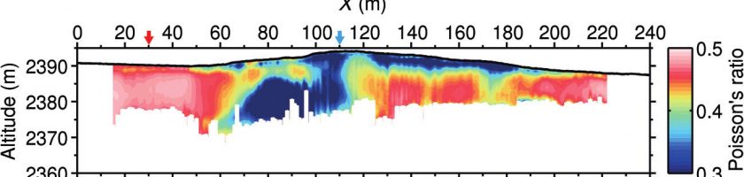
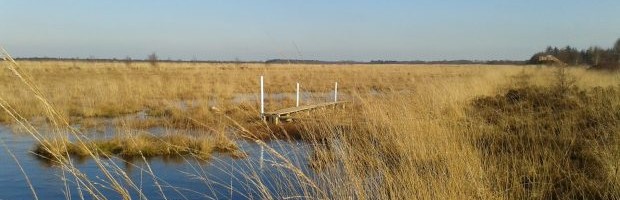
SWIP: un workflow intégré pour l’inversion et le profile de la dispersion des ondes de surface

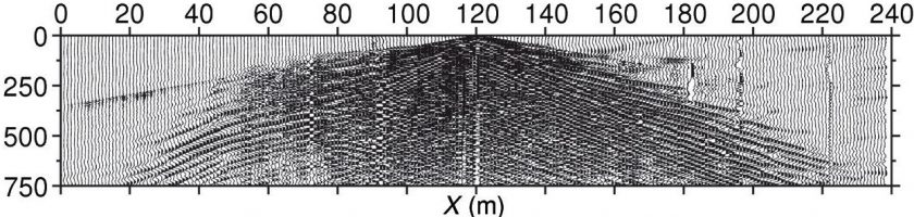
SWIP est une boîte à outils développée par Sylvain Pasquet qui fournit un workflow intégré pour l’inversion et le profilage de la dispersion des ondes de surface, récemment appliqué avec succès à l’imagerie de la zone critique. Un tutoriel a été publié en géophysique : Sylvain Pasquet et Ludovic Bodet (2017). « SWIP: An integrated workflow for surface-wave dispersion inversion and […]

Read more

SWIP: An integrated workflow for surface-wave dispersion inversion and profiling

The simultaneous estimation of 2D pressure (P-) and S-wave velocities (VP and VS, respectively) is a promising approach for imaging subsurface mechanical properties. It can be performed with a single acquisition setup by combining P-wave refraction and surface-wave (SW) analysis. Although SW methods are commonly applied for the 1D estimation of VS, 2D profiling requires the implementation of specific processing […]

Read more

Neutrally buoyant tracers in hydrogeophysics: Field demonstration in fractured rock

Electrical and electromagnetic methods are extensively used to map electrically conductive tracers within hydrogeologic systems. Often, the tracers used consist of dissolved salt in water, leading to a denser mixture than the ambient formation water. Density effects are often ignored and rarely modeled but can dramatically affect transport behavior and introduce dynamics that are unrepresentative of the response obtained with […]

Read more

Evaluation and localization of an artificial drainage network by 3D time-lapse electrical resistivity tomography

Papers - Publications scientifiques

In France, 10 % of total arable land is equipped with subsurface drainage systems, to control winter and spring waterlogging due to a temporary perched water table. Most of these systems were installed in the 1980s and have aged since then and may now need maintenance. Sometimes, the location of the systems is known, but the standard situation in France […]

Read more

CRITEX, Guide de la R&D, 2016

CRITEX est un projet financé par le Programme d’Investissements d’Avenir visant le développement de capteurs pour l’étude de la zone critique de la Terre, c’est à dire cette zone comprise entre le ciel et les profondeurs de la Terre sur laquelle l’humanité vit, dont elle se nourrit et où elle stocke ses déchets. Ce programme associe plusieurs organismes de recherche […]

Read more

SHYDRO2GEO-Spatialisation des paramètres hydrologiques à l’aide de méthodes géophysiques et géostatistiques

La recherche sur la zone critique (ZC) est une condition préalable pour aborder les problèmes liés aux services écosystémiques dont dépendent les sociétés humaines (cycle des nutriments, approvisionnement en eau et qualité). Cependant, si la partie supérieure de la ZC (végétation, sol, eau de surface) est facilement accessible, la connaissance souterraine reste limitée, en raison du caractère ponctuel des observations […]

Read more

Small-Scale Seismic Monitoring of Varying Water Levels in Granular Media

Papers - Publications scientifiques

Physical properties of soils in the vadose zone, and especially their water content, are characterized by strong spatial and temporal variations mostly driven by weather and anthropogenic activities. To understand this variability and help water resource management, seismic methods have been recently suggested as a complement to electrical and electromagnetic techniques. The simultaneous in situ estimation of pressure (P) and […]

Read more

2D characterization of near-surface VP/VS: surface-wave dispersion inversion versus refraction tomography

Papers - Publications scientifiques

The joint study of pressure (P-) and shear (S-) wave velocities (VP and VS), as well as their ratio (VP/VS), has been used for many years at large scales but remains marginal in near-surface applications. For these applications, VP and VS are generally retrieved with seismic refraction tomography combining P and SH (shear-horizontal) waves, thus requiring two separate acquisitions. Surface-wave […]

Read more

3ème Workshop sur l’Hydrogéophysique AGU-SEG : Imager de la Zone Critique

 Le 3ème worksjop d’hydrogéophysique de l’AGU et la SEG – imager la Zone Critique – aura lieu à Stanford, California du 24 au 27 juillet 2017. Dans ce workshop, les organisateurs proposent de développer un cadre pour faire avancer à la fois l’hydrogéophysique et les recherches sur la Zone Critique, par une coordination des agendas. Les méthodes d’hydrogéophysique permettront de […]

Read more
1 2 3