Tag Archives: Hydrologie

Passive temperature tomography experiments to characterize transmissivity and connectivity of preferential flow paths in fractured media

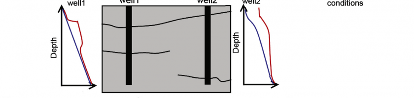
The detection of preferential flow paths and the characterization of their hydraulic properties are major challenges in fractured rock hydrology. In this study, we propose to use temperature as a passive tracer to characterize fracture connectivity and hydraulic properties. In particular, we propose a new temperature tomography field method in which borehole temperature profiles are measured under different pumping conditions […]

Read more

Evaluation and localization of an artificial drainage network by 3D time-lapse electrical resistivity tomography

Papers - Publications scientifiques

In France, 10 % of total arable land is equipped with subsurface drainage systems, to control winter and spring waterlogging due to a temporary perched water table. Most of these systems were installed in the 1980s and have aged since then and may now need maintenance. Sometimes, the location of the systems is known, but the standard situation in France […]

Read more

CRITEX, Guide de la R&D, 2016

CRITEX est un projet financé par le Programme d’Investissements d’Avenir visant le développement de capteurs pour l’étude de la zone critique de la Terre, c’est à dire cette zone comprise entre le ciel et les profondeurs de la Terre sur laquelle l’humanité vit, dont elle se nourrit et où elle stocke ses déchets. Ce programme associe plusieurs organismes de recherche […]

Read more

Une zone si critique

L’humanité se rassemble sur une fine pellicule de la planète qui va des sols à la basse atmosphère et inclut tout le vivant : un espace pour notre survie qui ne se laisse pas étudier si facilement. Spécialistes en géosciences, Nicolas Arnaud et Jérôme Gaillardet nous en disent plus sur ce que l’on appelle la « zone critique ». Copyright […]

Read more

SHYDRO2GEO-Spatialisation des paramètres hydrologiques à l’aide de méthodes géophysiques et géostatistiques

La recherche sur la zone critique (ZC) est une condition préalable pour aborder les problèmes liés aux services écosystémiques dont dépendent les sociétés humaines (cycle des nutriments, approvisionnement en eau et qualité). Cependant, si la partie supérieure de la ZC (végétation, sol, eau de surface) est facilement accessible, la connaissance souterraine reste limitée, en raison du caractère ponctuel des observations […]

Read more

3ème Workshop sur l’Hydrogéophysique AGU-SEG : Imager de la Zone Critique

 Le 3ème worksjop d’hydrogéophysique de l’AGU et la SEG – imager la Zone Critique – aura lieu à Stanford, California du 24 au 27 juillet 2017. Dans ce workshop, les organisateurs proposent de développer un cadre pour faire avancer à la fois l’hydrogéophysique et les recherches sur la Zone Critique, par une coordination des agendas. Les méthodes d’hydrogéophysique permettront de […]

Read more

Field Continuous Measurement of Dissolved Gases with a CF-MIMS: Applications to the Physics and Biogeochemistry of Groundwater Flow

In the perspective of a temporal and spatial exploration of aquatic environments (surface and groundwater), we developed a technique for field continuous measurements of dissolved gases with a precision better than 1% for N2, O2, CO2, He, Ar, 2% for Kr, 8% for Xe, and 3% for CH4, N2O and Ne. With a large resolution (from 1 × 10⁻⁹ to […]

Read more

Hydrogeophysical characterization of transport processes in fractured rock by combining push-pull and single-hole ground penetrating radar experiments

The in situ characterization of transport processes in fractured media is particularly challenging due to the considerable spatial uncertainty on tracer pathways and dominant controlling processes, such as dispersion, channeling, trapping, matrix diffusion, ambient and density driven flows. We attempted to reduce this uncertainty by coupling push-pull tracer experiments with single-hole ground penetrating radar (GPR) time-lapse imaging. The experiments involved different injection fractures, chaser […]

Read more

Contribution of the finite volume point dilution method for measurement of groundwater fluxes in a fractured aquifer

Measurement of groundwater fluxes is the basis of all hydrogeological study, from hydraulic characterization to the most advanced reactive transport modeling. Usual groundwater flux estimation with Darcy’s law may lead to cumulated errors on spatial variability, especially in fractured aquifers where local direct measurement of groundwater fluxes becomes necessary. In the present study, both classical point dilution method (PDM) and […]

Read more